Sunday, 7 July 2013

July 6, 2013 - Marble River


July 6, 2013 – Up Marble River

We said good bye to Coal Harbor and pulled up anchor around noon (watching for Jeff’s plane possibly flying overhead en route to Seoul !) …. and headed to Varney Bay (near the end of Rupert Inlet) for the afternoon, where we dropped anchor and tenders and headed to Marble River (which drains from Alice Lake – for those of you with Google Earth !!)

It is a most beautiful, ethereal spot … a gorge with steep rock walls, beautiful clear water anywhere from 1-8 feet deep and lush, vegetation hanging off the sides of the rock …. STUNNING.
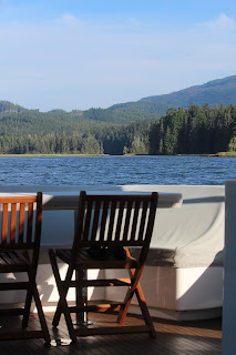
The view from where we anchored … beyond, is the mouth of Marble River


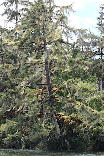
A tree at the mouth of the river - her moss “dress” (Versace I believe) floating in the breeze.


Talbots at the front of the dinghy on “rock watch” … much like Baywatch but I couldn’t talk Penny into wearing the red Speedo bathing suit.


Heading down the river …..


Christopher, Diana and Codi ...


Denis kayaked the river …..


Coming back out the mouth of the river with our boat just beyond.


From here, we pulled anchor and headed back through Quatsino Narrows and back to Julian Cove for a quiet ( and wind less) night and CRAB dinner!!!!!

SUCH AN AMAZING DAY !!!!!!!!!!!!!

AND … it’s looking like the weather is improving and we MAY be able to head around Brooks Peninsula by … Tuesday ?!?

Saturday, 6 July 2013

July 5, 2013 - Quatsino Narrows


July 5, 2013 – A trip through Quatsino Narrows
It’s hard to believe when one wakes up in a quiet little bay with NO wind, that it is “blowing to beat 60” out in the ocean but apparently it is …. And we are here in Quatsino Sound, until it lets up.
 
... SEND FOOD …. We may be here for days !!  :-0 


Cam here!
This is why we are staying inside Quatsino Sound (see below).


Blue is “good”, red is “bad”.

As you can see virtually all of Vancouver Island is “bad” (until at least early next week). The following photo indicates winds up to 35kn (65km/hr.) with waves up to 4m (13ft). This is supposed to be fun so I don’t think we’re going upstage the World’s Deadliest Catch crew.
Remember what I said earlier; heavy-duty boat …. light-weight crew. 
So… we’ll just sit tight until things settle down and then make a dash around Brooks Peninsula (which is likely the toughest stretch of water we’ll encounter on the whole trip.

Back to Kim…..
 

Funny …. Red USED to be my favorite color.  NOT so much anymore …..  :-?
And “dash”? …. I don’t know if I would classify 8 knots as a DASH ….

Cam and I ran down to Port Alice in the tender in the am (about a 20 min ride) to pick up some provisions and possibly top up the fuel in the tender.  Not a lot in Port Alice …. We tied up to the dock at the “Port Alice Yacht Club” only to head up to the top of the ramp and find the door LOCKED.  Clearly Royal Van Yacht Club does not have reciprocity with Port Alice Yacht Club?!?  BUMMER ….. So close, yet so far …. No fuel and no provisions for us.  However, we WILL survive …. 

We headed back to Julian Cove and pulled up anchor to time our trip through Quatsino Narrows at high slack.   

Quatsino Narrows … swirly but other than that, a piece of cake.


Once through, we headed to Varney Bay but felt it was "a little too little" for the three of us, so we have found ourselves at Coal Harbor, at least for the afternoon.  (We may head back through the narrows at evening slack and head back into Julian Cove as it is blowing 15-20 knots here in Coal Harbor!!)
... Late afternoon and still in Coal Harbor but the wind has settled a little so we are anchored (separately) and here for the night! 


We went in to “town” to check out the facinating museum by the marina.  It is put together by a fellow named Joey who has done a remarkable job of documenting the history of the area (especially the RCAF) & collecting items - a chainsaw collection, the original and only,  Hornsby Crawler Tractor ( precursor to the CAT), an old vintage car and a firetruck  that he has restored, engines, tools, props - "stuff" he has collected over the years.  
Joey gave us a personal tour of his museum .... he is a very interesting fellow, and quite the character.
He has fabulous photos, stories and items  that he has collected, of past whaling activities in the area including a huge whale jaw bone on display. 

 
Headed back to the boats for a delish dinner of bbq’d turkey sausage & cabbage etc (NO CRAB !!) and then “True Lies” movie (can we EVER get enough of Jamie Lee Curtis doing her “pole dance” ??)  WITH popcorn, of course afterwhich everyone headed back to their own boats and off to bed.

Friday, 5 July 2013

July 4, 20143 - Hanging in Julian Cove


July 4, 2013 -  A Quiet Day in Julian Cove

We stayed put in this lovely bay and spent the day kayaking, checking crab and prawn traps and generally hanging around the boats …. Cam dealt with an inverter issue (there is always SOME issue on at least one of the boats ….)  Ours was thankfully a very simple fix … as simple as a “flick of the switch” (how did THAT get turned off ??? Wasn’t ME !!! Seriously … it wasn’t ME … ) 

I cleaned the tender in preparation for getting her new decals put on (name and registration number). 

We had a lovely barbq’d salmon and cod dinner AND Denis (Christopher and Diana’s son) made s’mores for dessert …. AWESOME!!!
 
Checked the crab and prawn traps at the end of the evening …. Skunked …. I guess  it’ll be “beans and wieners” for dinner tomorrow !!!!  :-?

Thought this pretty much summed up our day today …. Cody “just hangin’ ….”   J


Thursday, 4 July 2013

July 3, 2013 - Julian Cove


( BTW .... Yesterday's "stardate" was posted on the 3rd, but was actually about activities for the 2nd .... in case you're closely following the dates.)


July 3, 2013 – in Julian Cove

We left Winter Harbor after spending a relaxing morning chatting with the locals & fuelling up the dinghys.  The folks at the Qualicum Rivers Resort (at the government docks) run a “ship shape” lodge and are SO friendly (as everyone in the village seem to be) …. AND they have wifi (albeit painfully slow to download photos to this blog …. 2 HOURS for 16 photos ! YIKES !! ).  It’s a LOVELY little community.  As it turns out, there is a connection between Penny’s friend Lynn and the very nice fellow who traded "wine for fish" with me, although the connection wasn’t made until this morning.  Such a small world !! 

We ran into (probably a better expression would be "met up with" since we never want to "run into" anyone with our boat ... )  a couple of sailboats that shared our dock back in Port Hardy.  They left the same day we did and made the trek into Bull Harbor and then around the top of the island and pulled into Winter Harbor today … and there they were sitting outside The Outpost store as I walked by!!  They are generally heading in the same direction as we are and we will likely see them again on our way south ….

The scenery on the trip to Julian Cove, up Quatsino Sound is beyond spectacular… water, rocks and Christmas trees, Bill ???  (little inside joke with Mr. Cosman) ….

It is VERY remote with only a few signs of people at the various fish farms we saw en route, however, pulling into Julian Cove, there were two other boats …. I guess someone forgot to phone ahead and reserve.  J  There was room for everyone as we rafted together with Colibri and Malahide.

We dropped the dinghy’s and kayaks, ran some crab & prawn traps out into the sound and spent the evening enjoying the beautiful surroundings and feasting on scallops & salad, salmon chowder and rhubarb crumble with ice cream …. watched GALAXY QUEST (hysterical movie) then checked out the stars around midnite.  SPECTACULAR.

Checked the traps before the sun went down and other than a few prawns (Talbots trap)  and a honking big dog fish and one teeny crab ( Kemps trap) we didn’t catch much.  We will check them again tomorrow, but it looks like chicken for dinner tomorrow nite !!! 

Quatsino Sound …. never get tired of "water, rocks and Christmas trees" …. .


Malahide pulling into Julian cove


Penny kayaking around the bay …. Boats rafted …..


Wednesday, 3 July 2013

Captain's Log - Stardate - 03-07-13


Captain's Log … Stardate – 03-07-13

AIS.... or ... “where the hell did they go?”

I’m sure most of you have noticed that we appear and (mostly) disappear on marinetraffic.com.

The reason is that boats with AIS transmit their position information via VHF radio which has, under ideal conditions, a range of about 40 to 50 miles. This typically works fine for boat-to-boat communications as 40 to 50 miles is plenty of range to see what other boats are around you. For you to see us on marinetraffic.com our signal needs to be picked up by a land-based receiving station which, based on where we have been, appears that there aren’t very many. Each time we get close to a town like Port Hardy we typically reappear only to disappear as we head off into more remote areas.
Never fear we are still here.       

For those of you that might be interested in the more technical aspects of our trip here are some of the details.

The Boat

The boat has run flawlessly since we left. One of our bigger challenges when we first bought the boat was with the autopilot. It would go into alarm mode frequently, wouldn’t steer the boat in a straight line and occasionally would throw the boat into a full hard-rudder turn whenever it felt like it. After much detective work and assistance from a couple of great marine techs in Anacortes we have determined what the problems were and solved them. The autopilot system has worked perfectly the whole trip. Thank you Tom and Brian.

Before we left Anacortes we filled all the fuel tanks so the boat sits heavy in the water which, when the seas get rough, greatly adds to the stability of the boat and ride comfort. Watching our boat’s motion compared to the other two in our armada we move around a lot less.

Navigating

Typically before each days trip I enter our route into the chart plotter and then turn it on as we leave. This allows me (or Kim) to sit back and watch for wood or seaweed in the water and other boats. At each waypoint I simply acknowledge the required turn to the next waypoint and off we go on the next leg. Pretty easy.

Coming around the top of the island it was very foggy and the radar system was invaluable as there are a lot of small fishing boats out there with no AIS or, seemingly, even a VHF radio. As we came around Cape Scott the fog was so thick that we could only see approximately 150 feet which isn’t a big deal as the chart plotter and autopilot were keeping us on course. The excitement started when I picked up small boats moving at approximately 20 kn coming directly towards us in the thick fog. I started taking evasive action trying to figure out which way to turn to get out of their way while trying to raise them on the radio and honking the ships horn to let them know we were in front of them. It’s pretty freaky to see a small fish boat come thundering out of the fog at 20 kn a hundred feet away from you and see their surprise when they saw us.

That happened a couple of times and wasn’t a lot of fun. Without the radar we would not have even known they were out there.

There should be a minimum IQ test before letting people run a boat. Based on what I’ve seen a high percentage of them wouldn’t pass. 

Communications

Before we left I set up three different ways to communicate from the boat;

·        Wi-Fi

The boat has a Wi-Fi amplifier on board which allows us to connect to any available Wi-Fi sites even if we are a fair distance away. This has worked well when we’ve been in marinas (which hasn’t been all that often) but it is the cheapest way to communicate and access the Internet.

·        3G

I installed a 3G system on board which allows us to use Kim’s Telus Sim card and access cellular coverage if it is available. The system is connected to a large antenna on the top of the boat which gives us much better range than you would get simply with your cell phone. This system has worked very well through most of our trip but started to drop off as we left Port Hardy. We are currently in Winter Harbour which has no cell coverage at all.

·        Satellite Phone and Internet

I had this system installed before we left knowing that we would have no Wi-Fi or 3G coverage for major portions of our trip. The satellite phone and Internet system gives us full communications virtually anywhere and has worked perfectly. It’s not very fast (Internet) and can be expensive if you use it a lot but we are being careful with our Internet usage and phone calls are only $.49 per minute. The Internet usage has been primarily to check weather data.

So….. That’s probably more technical information than most people wanted but for those that are interested there you have it.

The weather forecast is for 30 to 40 kn Northwest winds off the west side of Vancouver island for the next few days and as we have to go around a particularly nasty stretch of coast called the Brooks Peninsula we are going to sit tight and wait until things have settled down.

Once the weather conditions are good we will give Brooks Peninsula a wide berth and jump down to the next sound which is Kyuquot Sound.

More to follow later.

Cam

(Kim here ….)  Now that all that we’ve got all that “technical chit chat ” out of the way, let’s get on with “ a day in the life …” J

So … Here’s an otter family that we woke up while blasting around the harbor in our dinghy ….. Winter Harbor is overrun with these adorable little critters … hence no crabbing nearby (according to the locals). 


Penny, Christopher and Diana went out fishing and caught a cod and a good sized salmon.  I chatted up one of the fishermen on the dock and, in exchange for a bottle of red wine, “caught” a good sized salmon also!!!  J  We had mine for dinner!!! 

Sharing a little champagne with Jon and Sue !!
 
Sunshine …. Fishing …. Walks …. Relaxing … Eating …. Drinking ….. Friends …. Boat rides ….

It’s what holidays are made of  J

Tuesday, 2 July 2013

July 1, 2013 - Canada Day in Winter Harbor


July 1, 2013 – HAPPY CANADA DAY

We awoke to overcast skies and moderate winds, and, along with the two sailboats who shared the cove with us,  Colibri and Sea Level II pulled up anchor and headed out into the “open ocean” of the west coast.


We headed to Winter Harbor in the very beautiful Quatsino Sound.  The weather is supposed to get snarly over the next 5 days so our plan is to hold up in this very large sound and check out all the narrows, inlets and bays while we there …..

Thanks to JAMES from Stryker Marine in Pt Hardy, Malahide received her radar parts last night and had them installed late into the evening.  They have fuelled up and are underway to catch up to us.

The winds out in the ocean were 15-25 knots on our starboard stern, so it was “mildly lumpy” (another technical nautical term). 

 First (and only) mate Kim, giving the captain a break ….

 
The lighthouse at the entrance to Quatsino Sound ….


We made our way into Winter Harbor …. a  T I N Y  fishing community - pretty much all recreational fishing from what I can see. There is a scattering of “resorts” and cabins along the shore, along with a charming little boardwalk skirting the shoreline.

 
 It is beautiful in here and the people are super friendly and charming ….

The Winter Harbor post office (where I will be mailing a post card to my niece Emily who is at camp and anxiously awaiting mail)  J


The boardwalk along the shore …..

 
A beautiful sculpture along the boardwalk …..


Malahide arrived safely, after their very long day …. Just around dinner time. 
The Three Musketeers are together again !!!

June 30, 2013 - Rounding the Northern tip


June 30, 2013 – Rounding the Northern Tip

Malahide is having radar issues but as our weather window to getting around the top end of the island is closing , Colibri and Sea Level II opt to leave Pt Hardy and head to Bull Harbor and, weather dependant,  possibly all the way around to Sea Otter Cove.  Hopefully the necessary radar parts will arrive today and Malahide will follow us around tomorrow.


As we worked our way up to the northern end of the island through Goletas Channel, the weather was spectacular and the seas were absolutely calm.

We hit some very dense fog just before Bull Harbor and the little fishing boats (without radar and seemingly without radios!!) darted around us, making for a bit of a tense part of the trip.  We were picking up images on our radar, so we knew something was out there and coming towards us … Cam was sounding our horn to make sure boats knew we were there and little fishing boats would fly out of the fog, wave and disappear back into the fog ….
Gotta love those little fishing boats …. NOT !!


 Colibri coming through the fog behind us ….


As we work our way out of the fog Colibri is much more visible behind us now …..


Over the last year of preparation for this trip, there had been much discussion and reading about  how to handle THE NAWHITTI BAR and TATNALL REEFS ( the mention of these “strike fear in the hearts of men” …. AND women !!)  These can be very treacherous and in certain weather conditions, very challenging.  We opted to not cross directly over the bar, but instead hug the north tip of the island and skirt the bar and the reefs.
We could  not have had better weather conditions!!  Christopher (in Colibri) said in ALL the times he has been in situations like these (and he has come across bars before …), he has never experienced such calm conditions ….

Prayers answered !!   J
Reaching the most northerly point on our journey around the island …. Winds are 3.2 knots … it’s 14’ outside and we are flying along at 8 knots for another 14 min 46 seconds until we make the turn to start heading south …


We saw sea otters, seals AND a whale feeding (YEAH !!  I finally saw a whale … )
 
 With the fog cleared, we enjoyed blue skies and warm sun the rest of the way ‘round.  We could now actually SEE the beautiful rugged shores ….


The wind picked up a little as we rounded the point and headed to Sea Otter Cove.  The cove has a very rugged entrance with rocks and enormous kelp patches.  The kelp beds looked a little like something out of an alien movie !!


We worked our way through the rocks,  into the VERY shallow Sea Otter Cove and dropped anchor. 


With only 14’ of water below us and an expected tidal drop of 7’ overnight, we pulled our anchor and opted to raft overnight with Colibri, who had found a 22’ deep hole.

 Here’s what came up with our anchor …  A bouquet of seaweed and mud !!!  NICE !!


Safe and sound for another nite …..